Posted: April 24, 2025
Geopedological survey reveals centuries-old cultivation systems still shaping soils and microhabitats in northwestern Ireland.

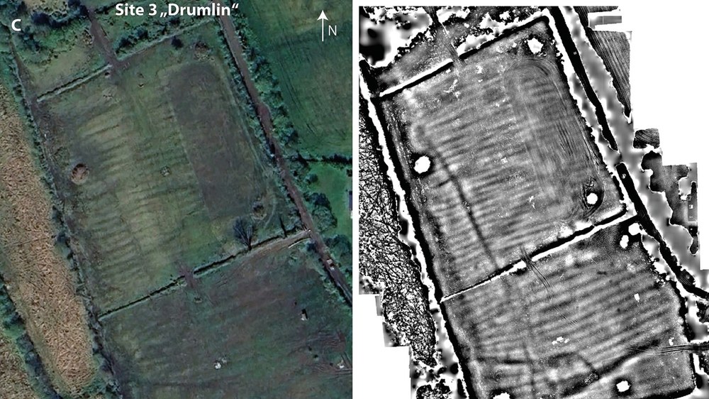
Comparison of aerial photograph (left) and digital elevation model or DEM (right)
A new study published in Geomorphology has uncovered striking evidence that historic raised bed (RB) field systems (constructed manually more than 170 years ago) continue to influence soil properties and moisture patterns in northwestern Ireland today.
Led by Alexander Bonhage (Brandenburg University of Technology), with collaborators from BTU and the Pennsylvania State University, including Dr. Patrick Drohan, the research marks the first geopedological survey of these anthropogenic landforms in the region. Raised beds, sometimes called "lazy beds," were widely used across Ireland to drain marginal, wet soils and grow staple crops like oats and potatoes. Their use declined after the Great Famine (1845–1849), yet their structural footprint remains visible in many areas.
"Although these features were abandoned generations ago, our findings suggest their hydrologic function persists, altering soil wetness, nutrient distributions, and potentially influencing local biodiversity," said Bonhage.
Using drone-based photogrammetry, the team produced high-resolution digital elevation models (DEMs) of three distinct RB sites in Leitrim and Roscommon counties. The data revealed nuanced differences in ridge spacing and furrow depth—factors closely tied to soil parent material, slope, and historical land use practices.
"We found that DEMs with a resolution finer than 50 cm are necessary to reliably identify these features, especially where ridge spacing is narrow or vegetation is dense," said Drohan.
The team's hydrologic modeling showed that furrows retained more moisture than ridges—replicating the drainage patterns originally intended by 19th-century farmers. These patterns persisted even on sites used as pasture for decades, highlighting the long-term ecohydrological imprint of RB systems.
Soil sampling revealed statistically significant differences in nutrient concentrations, including phosphorus and potassium, between ridge and furrow positions. These disparities likely stem from a mix of historical fertilization, moisture retention, and ongoing grazing effects.
The research has broader implications for soil conservation, cultural heritage preservation, and land management under changing climate conditions.
"These are not just relics of the past," Bonhage emphasized. "They are living landscapes whose geomorphic and pedogenic legacies remain active. As we grapple with sustainable land use, acknowledging these legacies is essential."
The study also warns of challenges in mapping and conserving RB sites, especially given the limitations of freely available satellite imagery and the cost of high-resolution LiDAR in Ireland. The authors call for expanded remote sensing efforts, combined with field verification, to develop a national inventory of remaining RB sites.
"This is a foundation for future work," said Drohan. "Understanding the persistence of land-use legacies is key to predicting soil behavior and managing landscapes long after cultivation has ceased."
The full article, "An initial geopedological survey and description of historic raised beds in north-western Ireland," is available open-access in Geomorphology [DOI: 10.1016/j.geomorph.2025.109778].

