Posted: April 17, 2023

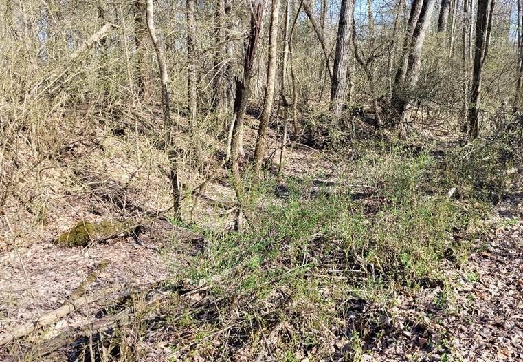
In the photograph above, taken on April 10, 2023 in Centre County, PA, nearly all of the green visible is foliage from invasive shrubs and biennials. This area is significantly impacted.
Written by Jeff Osborne, Forest Stewardship Program Associate, James C. Finley Center for Private Forests at Penn State
University Park, PA – April 14, 2023 – There are better times of the year to walk through areas to identify populations of invasive species – plant and insect – because either they are more prominent or because they are in a stage that you will count and get an idea of their future effect. Although traveling on foot will give you the best idea of what is happening in your woods, there are online tools you can use to see defoliation caused by Lymantria dispar dispar, aka spongy moths, and other insects on your property and the surrounding area.
Early to mid-April may be a great time to walk through the woods and see green from many shrub and biennial non-native invasive species (NNIS) and get a sense for their future impact on the landscape before most native shrubs have started developing their leaves. Currently, in the center part of the state, some of the most common NNIS, Lonicera spp. (honeysuckle), Ligustrum spp. (privet), Elaeagnus spp. (olive), and multiflora rose, are nearing 50% leaf expansion, and the basal leaves of perennial invasives, like garlic mustard, and those in the parsnip family are plainly visible. There are some populations of the invasive burning bush, Euonymus alatus, which have just started push out leaves. There are some native shrubs that send out leaves earlier in April, like Sambucus spp. (elderberry) and some non-natives that green up around the same time as many natives later in the season. So, it is important to be able to identify the green you see before you start to plan any control regime. If you find you have many invasive plant species, you may want to act. At the end of the growing season, many NNIS retain their leaves a few weeks longer than natives, but by that time you have fewer treatment options left that year.
If you decide to act, it may be an impossible, and unnecessary goal to remove every non-native plant, but reducing their growing space will allow more growing space for other native shrubs and spring ephemerals which often have pleasing flowers and are of ecological importance. You should consider the concepts of integrated pest management before you start dealing with invasives. The US Environmental Protection Agency outlines four logical stages to pest management: 1) Monitor and Identify Pests, 2) Set action thresholds, 3) Prevention, and 4) Control. Frequently traveling your property along roads, trails, and recently disturbed areas identifying and controlling small populations can save you from a larger investment later. PSU Extension has many guides to identify and treat invasive and competing plants in video and print form. The Bureau of Forestry also list their priority invasive species for each forest district. By learning to identify and monitoring for these species, you can try to stay one step ahead.
NNIS plant management requires on-the-ground observation; other NNIS insects and disease may require tools at multiple scales to see their impacts and make management decisions. While surveys for spongy moths are best done in fall after they have completed laying eggs so you can estimate their number of egg masses per acre,. you can walk around in late May through June to observe defoliation. You can also use free online tools, which may be especially helpful if you live apart from or manage a large forest. Sentinel Hub Playground provides satellite imagery every five days, some at 10-meter resolution, which can be very helpful in spotting defoliation from spongy moth. Every five days seems great, but you may encounter many images where the ground is obscured by clouds. It would only be helpful spotting invasive shrubs if you had a very thick shrub layer and little grass or overstory trees. It can also be helpful for scouting to hunt by checking on the status of crop fields, finding recent timber sales on land open to public hunting, or determining whether your remote property received snowfall. Another tool from NASA, Worldview, has a user friendly interface, and daily, but significantly lower, 250-meter resolution imagery. You can easily compare the change between dates, but the area affected by the change will have to be large to notice.

Image 2. Side by side images taken 17 days apart.
Green-up of plants is evident, especially in southeast PA
https://worldview.earthdata.nasa.gov
James C. Finley Center for Private Forests
Address
416 Forest Resources BuildingUniversity Park, PA 16802
- Email PrivateForests@psu.edu
- Office 814-863-0401
- Fax 814-865-6275
James C. Finley Center for Private Forests
Address
416 Forest Resources BuildingUniversity Park, PA 16802
- Email PrivateForests@psu.edu
- Office 814-863-0401
- Fax 814-865-6275

