Posted: August 26, 2024

Topographical map showing elevations and slopes
By Jeff Osborne, Forest Stewardship Program Associate
If you own property with steep slopes, they can affect the vegetation and how you manage your property. It can be useful to know how to measure property slope and the impacts of steeper slopes. Let’s look at some ways to measure slopes on-the-ground and remotely.
Slopes are commonly measured by degrees or percent slope. Percent slope is calculated by multiplying the tangent of the slope angle by 100. A 10-degree angle is a 17.7% percent slope, and a 15-degree angle is a 26.8% slope. There are several ways to determine slope. One way you can measure a slope is with a clinometer. For this you will need to have, or make, a clinometer, and then look up, down, or across the slope to another point that is the same height as your eye. You could even sight down the edge of a smart phone with a level to get an idea of a hill’s slope. You can also use simple, and free, smart phone apps or computer programs like Google Earth or CalTopo to get estimates of slopes.


The above left image is an excerpt from a screen shot from the Google Earth app. The point at the top of the image is directly downhill from the point at the bottom of the image. Google Earth can give us 150ft as the distance between the two points without considering slope and then elevations for each point in another window. In the middle are the simple calculations you can use to determine the slope and the travel distance between points. To the right is a screenshot from a level app on a phone held along a sight line between the two points. It is about a degree off the calculation but is quicker to get an estimate of slope.


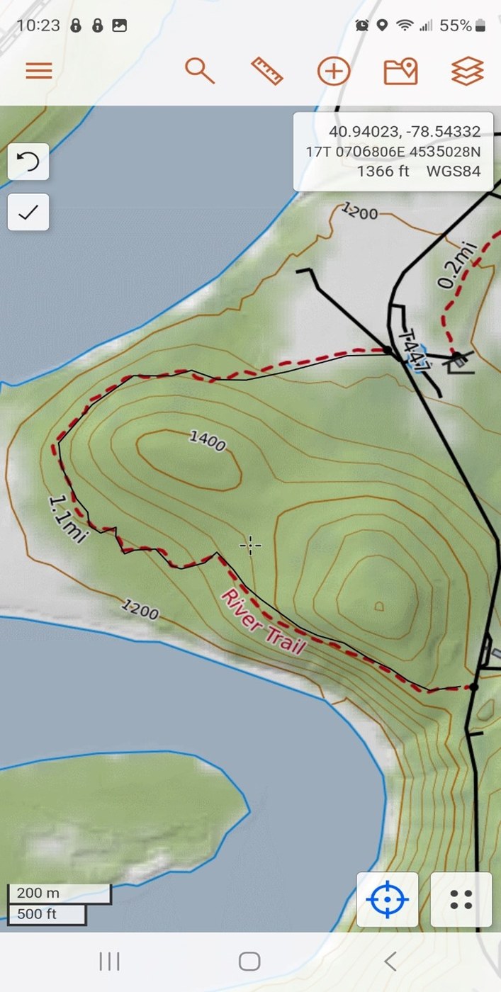
The two screen shots above are from the free CalTopo app. On the left is a topographic map which has trails shown with red dashed lines. Under the ruler drop-down menu, you can select “profile”. Once selected you can plot a path along the trail. Your line will be denoted by a thin black solid line like the one along River Trail. On the right is the slope, elevation, and forest cover of the path plotted out from the southern beginning of the trail to the northern intersection with a road. This shows information for elevation and slope. Steep slopes were only detected in the first quarter of the trail length.
How may slope affect your property? There are many effects of slope on vegetation. Soil moisture is affected by slope and aspect, or a slope’s orientation to toward the sun, which dries soil out. In the Northern Hemisphere there tends to be a soil moisture gradient depending on aspect. The gradient is, from more to less moist: north, east, west, south. Many tree species grow more quickly on north- and east-facing slopes than on south- and west-facing slopes due to increased soil moisture, and some will not be able to tolerate the dry conditions on steep south- and west-facing slopes. Many steep slopes are also rocky, contributing to lack of soil moisture. Some studies found a pH higher and closer to neutral, and higher amounts of major nutrients in the top 4 inches of the soil, on north-facing slopes as compared to south-facing slopes. Some species that can tolerate less water and more sun will do well on the south-facing slopes. These differences in slopes will also affect animal habitat. Some animals, such as snakes and other reptiles, may frequent sunny patches on steep south- or west-facing slopes to bask. Other wildlife may feed or rest in the different ranges of vegetation and topographic features found in sloped areas.
From a personal use standpoint, steep slopes can affect your ability to safely traverse your property in motorized equipment. Many popular ATV manufacturers list maximum uphill and downhill slopes for adult ATVs at something less than 25 degrees, and for youth ATVs, two-up ATVs, and UTVs at less than 10 or 15 degrees. Many manufacturers also have warnings about not traveling across slopes and slopes compounding the dangers of traveling across areas that are muddy, rocky, or frozen. You may not be able to find slope limitations for some off-road recreational vehicles and compact tractors. This is in part because the center of gravity can change with every implement that is added or removed and while operating some, like a front-end loader.
Measuring the slopes of an entire property can be done fairly quickly with free computer software and available data.

The slope map above, created with QGIS, a free software, and using data imported from the Pennsylvania Spatial Data Access (https://www.pasda.psu.edu/), shows six color-coded ranges of slope based on common limits of different equipment groups. You can clearly see trails that are yellow and green lines through the red areas that were likely created by a bulldozer to facilitate a timber harvest. You can see how the trails reduce the slope to something that was safe to operate the timber harvesting equipment and may be safe for some equipment, although some areas on the trails remain too steep for other equipment.
Once you get an idea of the slopes on your property and how they affect your goals for the property, you can make a plan to create or improve trails and manage vegetation within the confines that slopes may present. In the next news release, we will cover operating on slopes, including trail building techniques.
James C. Finley Center for Private Forests
Address
416 Forest Resources BuildingUniversity Park, PA 16802
- Email PrivateForests@psu.edu
- Office 814-863-0401
- Fax 814-865-6275
James C. Finley Center for Private Forests
Address
416 Forest Resources BuildingUniversity Park, PA 16802
- Email PrivateForests@psu.edu
- Office 814-863-0401
- Fax 814-865-6275

